drone inspection service

Drone Inspection Services

Safer, Faster, and More Accurate

Keep people off ladders and out of danger. Our commercial drones inspect what humans can't safely reach.

Utility poles. Solar farms. Substations. Buildings. Confined spaces. Pipelines. FAA certified pilots. Zero incidents. Nationwide service.

Get Your Free Quote - AltitudeWash

Services Needed (Select all that apply)

Commercial Drone Inspection Services

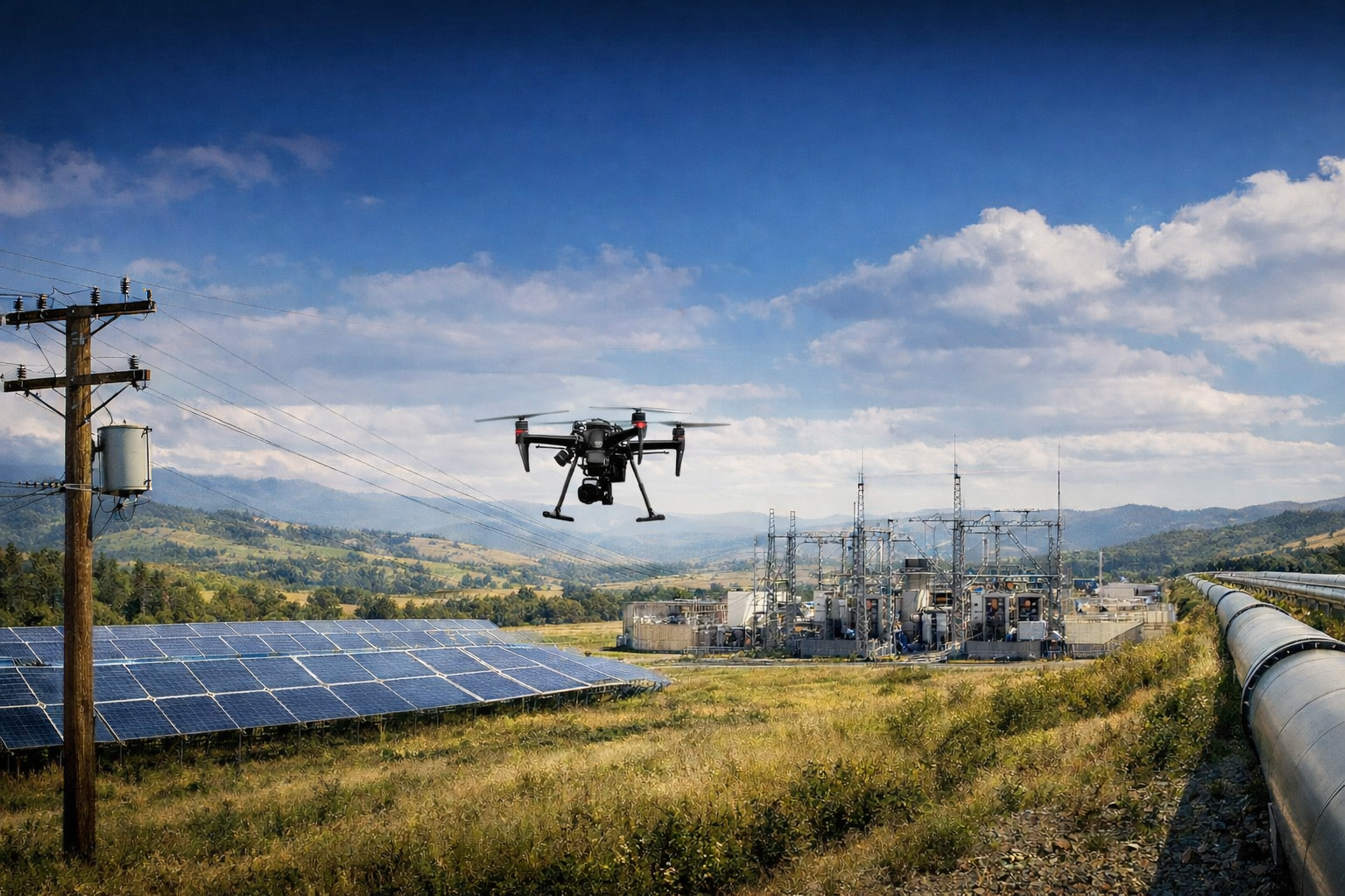
Our FAA Part 107 certified drone crews inspect critical infrastructure across the United States. We deliver high-resolution aerial data that keeps people off ladders, out of confined spaces, and away from hazardous environments — while providing better results, faster turnaround, and lower costs than traditional inspection methods.

From utility poles and solar farms to building facades and industrial tanks, AltitudeWash replaces dangerous manual inspections with safe, accurate drone technology. No scaffolding. No rope access. No shutdowns. Just the data you need to make informed decisions.

Contact AltitudeWash today to schedule your drone inspection.

Our Drone Inspection Services

We provide comprehensive drone inspection services for critical
infrastructure nationwide

Power Line & Utility Inspection

Pre-storm and post-storm assessment of electrical transmission and distribution infrastructure. Our drone crews inspect the structural integrity and safety of utility systems to help prevent outages, identify damage, and prioritize repairs — eliminating the need for bucket trucks, helicopters, or climbing crews in hazardous conditions.

Using high-resolution cameras, thermal imaging, and GPS-tagged deliverables, we identify damaged components, corrosion, vegetation encroachment, hotspots, and structural deficiencies across poles, crossarms, insulators, conductors, and related equipment.

Capabilities:

  • Storm Damage Assessment — Rapid-deployment crews photograph
    and document damage for restoration planning
  • Routine Pole Inspection (Blue Sky) — Scheduled circuit-by-circuit
    inspections averaging 40–50 poles per day
  • 12-photo standard protocol per structure (4 top, 4 middle, 4 bottom),
    GPS-tagged and organized
  • Thermal Imaging to detect hotspots, overloaded connections, and
    failing components
  • Transmission line sag measurement and clearance verification
  • Vegetation management surveys and encroachment documentation

Construction & Structural Inspection

Comprehensive aerial inspection of buildings, bridges, roofs, and other structures. Our drones capture high-resolution imagery of building envelopes, structural components, and hard-to-reach surfaces — eliminating the need for scaffolding, swing stages, or rope access teams.

From commercial high-rises to highway bridges, we deliver detailed visual documentation that engineers, property managers, and project owners need to assess condition, plan maintenance, and verify construction quality.

Capabilities:

  • Building facade and envelope inspection — identify cracks, water intrusion, deterioration, and missing components
  • Bridge and overpass structural assessment — document deck condition, support columns, joints, and bearings
  • Roof Condition Surveys — locate membrane damage, ponding, flashing failures, and drainage issues
  • Construction progress monitoring and QA/QC verification with timestamped photo documentation
  • Thermal/infrared moisture detection — identify trapped moisture, insulation gaps, and energy loss
  • Cell tower and telecom structure inspection — antennas, mounts, cabling, and structural integrity

Confined Spaces & Industrial Inspection

Drone inspection of enclosed and hazardous industrial environments where human entry is dangerous, expensive, or requires costly shutdowns. Our confined space drones inspect tanks, vessels, boilers, and other enclosed structures — eliminating manned entry, reducing downtime, and removing the liability of putting workers in IDLH (Immediately Dangerous to Life or Health) environments.

Every inspection is documented with high-resolution imagery and video, GPS-tagged and organized for engineering review, compliance reporting, and maintenance planning.

Capabilities:

  • Storage tank interior inspection — document wall condition, corrosion, coatings, and sediment without draining
  • Boiler and pressure vessel inspection — visual assessment of tubes, refractory, and internal components
  • Cooling tower assessment — inspect fill media, drift eliminators, structural supports, and basin condition
  • Silo and hopper inspection — check for material buildup, structural cracks, and liner condition
  • Stack and chimney surveys — document liner condition, refractory wear, and structural defects
  • Zero confined space entry risk — no ventilation setup, no rescue team standby, no entry permits required

Pipeline Inspection

Aerial and close-range drone inspection of pipeline infrastructure, rights-of-way, and associated facilities. Our drones survey pipeline corridors from above, identifying encroachment, erosion, third-party damage, and coating failures that ground patrols miss — covering more ground in less time with GPS-documented evidence.

Combined with thermal imaging, we detect leaks, temperature anomalies, and subsurface issues across transmission and distribution pipeline systems.

Capabilities:

  • Right-of-way corridor surveys — document encroachment, erosion, vegetation overgrowth, and access road condition
  • Corrosion and coating detection — identify exposed metal, coating disbondment, and surface degradation
  • Thermal leak identification — detect gas and liquid leaks through temperature differential imaging
  • Valve and pump station assessment — visual inspection of above-ground facilities, fencing, and signage
  • Post-construction verification — document as-built conditions, restoration, and compliance with permit requirements
  • Emergency rapid response — deploy within 24-48 hours for post-incident damage documentation and regulatory reporting

Solar Farm & Solar Array Inspection

Thermal and visual drone inspection of solar farms, rooftop arrays, carport canopies, and ground-mounted systems. Our drones scan entire solar installations from above, identifying underperforming panels, hotspots, cracked cells, and connection failures that ground-level visual checks miss — covering hundreds of acres per day with radiometric thermal and high-resolution RGB imaging.

AltitudeWash already maintains solar installations through our cleaning division. We understand solar infrastructure, panel layouts, and the operational demands of maximizing energy output. Our inspection service gives asset owners and O&M teams the data they need to prioritize repairs and protect revenue.

Capabilities:

  • Thermal hotspot detection — identify underperforming panels, failed bypass diodes, cracked cells, and shorted strings
  • Panel-level deficiency mapping — flag individual modules with GPS coordinates for targeted repair
  • Soiling and shading analysis — document dirt buildup, vegetation shadows, and bird debris affecting output
  • Racking and mounting inspection — check for corrosion, ground settling, loose fasteners, and tracker alignment
  • Inverter and combiner box thermal scan — detect overheating connections and failing components
  • Before/after cleaning verification — thermal documentation to confirm performance improvement post-cleaning

Substation Inspection

Thermal and visual drone inspection of electrical substations, switchyards, and distribution equipment. Our drones capture detailed thermal and RGB imagery of transformers, switchgear, bus bars, circuit breakers, and connections — identifying overheating components, oil leaks, corrosion, and equipment degradation without requiring personnel to enter energized environments.

Substation inspection is a natural extension of our utility pole inspection service. The same utility customers who need pole-by-pole circuit inspections also need regular thermal surveys of their substations to prevent equipment failure and unplanned outages.

Capabilities:

  • Transformer thermal scanning — detect hotspots indicating overloaded windings, failing bushings, or cooling system issues
  • Switchgear and circuit breaker inspection — identify overheating contacts, loose connections, and arc damage
  • Bus bar and conductor thermal survey — find high-resistance connections before they cause failure
  • Oil leak detection — visual identification of transformer oil leaks, staining, and containment issues
  • Insulator and arrester inspection — document cracked, contaminated, or flashover-damaged insulators
  • Perimeter and security documentation — aerial overview of fencing, access points, vegetation clearance, and signage compliance

Vegetation Management Surveys

Aerial drone surveys for utilities, pipeline operators, and transportation agencies to map and document vegetation encroachment along rights-of-way, transmission corridors, and distribution feeders. Our drones capture high-resolution RGB imagery and GPS-tagged data that vegetation management teams use to prioritize trimming schedules, document compliance, and reduce wildfire risk.

Utilities spend billions annually on vegetation management — it’s the single largest maintenance expense for most electric utilities. Drone surveys replace slow, inconsistent ground patrols with systematic aerial documentation that covers more ground, captures better data, and creates a permanent record for regulatory compliance.

Capabilities:

  • Right-of-way corridor mapping — document tree heights, canopy proximity, and clearance distances along power lines
  • Encroachment identification — flag vegetation growing within minimum clearance zones by structure and span
  • Trim cycle prioritization — provide data to help vegetation management teams route crews efficiently
  • Pre and post-trim documentation — aerial photos before and after clearing work for compliance records
  • Wildfire risk assessment — identify dead trees, dry brush, and high-risk vegetation in fire-prone corridors
  • Recurring survey programs — quarterly or annual flyovers to track growth rates and predict future encroachment

Why Drone Inspection Works

Traditional inspection methods are risky, time-consuming, and expensive. Drone-based inspections offer clear advantages:

Safety Icon

Safer for Everyone

Drones replace climbing crews, bucket trucks, and confined space entry. Zero incidents. Zero falls. Zero risk to your personnel.
Technology Icon

No Scaffolding Required

No lifts, no rope access, no lane closures. Drones reach any structure without setup time or equipment staging.
cost effective icon

30%-50% Cost Savings

Eliminate scaffolding rental, bucket truck mobilization, traffic control, and multi-person climbing crews. Drones deliver the same data at a fraction of the cost.
time-efficient

Up to 70% Faster

Inspect 40-50 utility poles per crew per day. What takes ground crews a week, our drones complete in a day.
drone icon

Reaches Any Height or Space

From 200-foot transmission towers to the inside of storage tanks, our drones go where people cannot safely reach.

High Resolution Data

48MP imagery, thermal/infrared, GPS-tagged deliverables. Every image is timestamped, geolocated, and delivered in utility-standard formats within 48-72 hours.
drone inspection service
Electric Pole Inspection

Infrastructure We Inspect

Our drone inspection services cover a wide range of critical infrastructure across every industry.
Drone inspecting electric tower for maintenance and cleaning
Utility Poles & Power Lines
industry icon
Buildings, Bridges & Roofs
Drone inspecting and cleaning large industrial tank exterior
Tanks, Boilers & Confined Spaces
Drone inspecting and cleaning industrial pipe exterior
Pipelines & Rights-of-Way
Drone inspecting and cleaning cell tower exterior
Cell Towers & Telecom
Drone inspecting solar panel system for cleaning and maintenance
Solar Farms & Arrays
electric-factory
Substations & Swithyards
vege field
Vegetation & Corridors
We serve the entire continental United States with 24-48 hour emergency deployment capability.
Call AltitudeWash for drone inspection services today.

Our Inspection Process

We follow a systematic, safe, and efficient process that delivers reliable results on every project. Our Drone Inspection Process:

1

Scope & Planning

We define the inspection area, structure count, sensor package (visual, thermal, LiDAR), deliverable format, and timeline. Airspace authorization and site access are coordinated in advance.

2

Site Assessment

Our crew reviews site conditions, identifies hazards, confirms flight zones, and verifies airspace clearance. Every job gets a documented safety plan before any drone leaves the ground.

3

Safety Setup

We establish a secure perimeter, conduct pre-flight safety briefings, and file flight plans per FAA requirements. Pilot and visual observer confirm all equipment and backup systems.

4

Precision Flight

Our FAA Part 107 certified pilot executes the inspection using our systematic 12-photo protocol per structure: 4 top, 4 middle, 4 bottom. Thermal pass included if scoped. 40-50 structures per crew per day.

5

Data Processing

All images are GPS-tagged, timestamped, and cataloged by structure ID, circuit, or feeder. Deficiency flagging with severity ratings is applied where applicable.

6

Deliverables

Digital photo packages are delivered within 48-72 hours in utility-standard formats (Lat/Long, KMZ, shapefile-ready). Summary report with inspection statistics and coverage map included.

Our drone inspection process ensures faster, safer, and more consistent results than traditional methods — even on the most complex infrastructure.

What Makes Our Inspection Different

Technology Icon
500+ Completed Projects
We didn’t start in a conference room. We built this company flying drones on high-rise buildings across LA and the Northeast — thousands of hours in tight urban airspace where precision and safety aren’t optional. That experience is now working for utilities and infrastructure owners.
Pilot Hat Icon
FAA Part 107 Certified Crews
Every mission is flown by FAA-certified pilots with dedicated visual observers. We carry commercial general liability insurance, aviation-specific coverage, and are ISNetworld and Avetta safety platform ready.
culture icon
Multi-Sensor Capability
High-resolution 48MP RGB cameras, radiometric thermal/infrared imaging, and LiDAR-ready platforms. We match the right sensor to your inspection requirements — visual, thermal, or both in a single flight pass.
Drone inspecting and cleaning United States building exteriors
Nationwide Deployment
We mobilize anywhere in the continental United States within 24-48 hours for emergency storm work, or schedule routine inspections with 1-2 week lead time. Fully equipped service vehicles with backup aircraft on every deployment.
excellence
Utility-Standard Deliverables
Every image is GPS-tagged, timestamped, and delivered in formats your GIS team can use — Lat/Long, KMZ, shapefile-ready. Organized by structure ID, circuit, or feeder. Summary reports with deficiency flagging and coverage maps included.
Safety Icon
Zero Safety Incidents
Zero incidents. Zero near-misses. Pre-flight safety briefings on every job. OSHA-compliant protocols for every environment we operate in.

Frequently Asked Questions

Common questions about our commercial drone inspection services

Power Line & Utility Inspection

How many utility poles can you inspect per day?

Our crews inspect 40-50 structures per crew per day at routine pace. For large programs, we deploy multiple crews to cover 100+ structures per day.

Do you inspect during active storms?

We don’t fly during active storms, but we mobilize within 24-48 hours after a storm passes for rapid damage assessment. Our crews arrive with everything needed — no utility support required.

What is the 12-photo protocol?

We capture 12 images per structure — 4 from the top, 4 from the middle, and 4 from the bottom. Every image is GPS-tagged and timestamped for GIS integration.

Construction & Structural Inspection

What types of buildings can you inspect?

We inspect commercial high-rises, office towers, apartment buildings, bridges, overpasses, parking structures, cell towers, and any structure where height or access makes traditional inspection difficult.

Can you detect moisture or leaks in buildings?

Yes. Our thermal imaging cameras detect trapped moisture, insulation gaps, and water intrusion behind walls and under roof membranes that are invisible to the naked eye.

Do you provide reports for engineers?

Yes. We deliver GPS-tagged, high-resolution photo packages organized by location and elevation, with deficiency flagging where applicable. Engineers and property managers use this data for maintenance planning and compliance.

Confined Spaces & Industrial Inspection

Does this eliminate the need for confined space entry permits?

Yes. Since no personnel enter the confined space, there is no need for entry permits, rescue team standby, ventilation systems, or atmospheric monitoring. This removes significant cost and liability.

Do you need to shut down operations for confined space inspection?

In many cases, no. Our drones can inspect tanks and vessels without requiring full shutdowns, draining, or ventilation setup — significantly reducing downtime compared to manned entry.

What confined spaces can drones inspect?

We inspect storage tanks, boilers, pressure vessels, cooling towers, silos, hoppers, stacks, chimneys, and other enclosed structures where human entry is dangerous or requires costly shutdowns.

Pipeline Inspection

How much pipeline corridor can you survey per day?

Coverage depends on terrain and detail level required, but our drone crews typically survey several miles of pipeline right-of-way per day with high-resolution imagery and GPS documentation.

Can you detect gas leaks with drones?

We use thermal imaging to detect temperature anomalies that indicate gas or liquid leaks along pipeline corridors. For specialized gas detection, we can deploy sensors calibrated for methane and other compounds.

Do you provide post-construction verification?

Yes. We document as-built conditions, restoration, ground disturbance, and compliance with permit requirements after construction or maintenance work on pipeline infrastructure.

Solar Farm & Solar Array Inspection

How do you find underperforming solar panels?

Our drones fly over the array with radiometric thermal cameras that detect hotspots — panels or cells running hotter than surrounding modules indicate cracked cells, failed bypass diodes, shorted strings, or connection failures.

Can you inspect rooftop solar arrays?

Yes. We inspect rooftop arrays, ground-mounted systems, carport canopies, and utility-scale solar farms. No roof access is required — drones scan from above.

Do you offer combined cleaning and inspection?

Yes. Since AltitudeWash already cleans solar installations, we can perform thermal inspection before and after cleaning to document performance improvement and identify panels that need repair versus just cleaning.

Substation Inspection

How do drones inspect substations safely?

Our pilots fly predetermined flight paths over and around substation equipment while maintaining safe distances from energized components. All flights follow utility-approved safety protocols and FAA regulations.

What problems can thermal imaging detect in substations?

Thermal cameras detect overheating transformers, loose bus bar connections, failing circuit breaker contacts, overloaded conductors, and deteriorating insulators — all before they cause equipment failure or unplanned outages.

How often should substations be inspected?

Most utilities perform thermal substation surveys annually or semi-annually. Critical substations or those with known issues may benefit from quarterly inspections, especially during peak load seasons.

Vegetation Management Surveys

How is drone vegetation survey different from ground patrol?

Ground patrols are slow, inconsistent, and limited by terrain access. Drone surveys capture high-resolution aerial imagery of entire corridors systematically, identifying encroachment that ground crews often miss — especially in areas with difficult terrain or limited road access.

Do you offer recurring survey programs?

Yes. We offer quarterly, semi-annual, or annual flyover programs that track vegetation growth over time. This gives utilities a permanent record for compliance and helps predict future encroachment before it becomes a clearance violation.

Can drones measure how close trees are to power lines?

Yes. Using high-resolution imagery and GPS data, we document tree heights, canopy proximity, and estimated clearance distances from conductors. This data helps vegetation management teams prioritize trimming schedules.

Ready to Get Started?

We’ll scope your inspection needs, provide a firm quote, and have crews on-site within days. No upfront capital investment, no equipment to purchase — just reliable aerial data delivered to your specifications.
Contact us to schedule a pilot program or request a quote for your next inspection cycle.
Get Free Quote TodayCall (888) 667-6008